Cities are increasingly looking to technology and data to address real-world issues, from traffic safety to law enforcement. The rise of generative artificial intelligence promises to make government more efficient but also poses equity and privacy risks, leading major cities to set use guidelines. Meanwhile, local leaders are discussing how to build public trust in the new technologies they are adopting.
The Smart Cities Dive editors are watching these developments to help city leaders better understand today’s world and prepare for the future. Read on for a selection of Smart Cities Dive’s coverage of the trends driving cities’ technology and data use
Free public Wi-Fi is now available via streetlights in South Los Angeles as the city prepares for the 2028 Olympic and Paralympic Games.
By: Ryan Kushner• Published Oct. 23, 2025
Several streetlights in the City of Angels now offer more than illumination — they offer free Wi-Fi as well.
The city of Los Angeles, in partnership with Cisco and community organizations Destination Crenshaw, the California Community Foundation and Digital Equity LA, launched a pilot program to provide free internet access across major streets, parks and public gathering spots along LA’s Crenshaw Corridor.
Years in the making, the project is designed to address Wi-Fi access gaps for residents and businesses in South LA. The LA Bureau of Street Lighting installed 1.5 miles of underground fiber optic cable across the corridor and worked with Cisco and Presidio, a technology integrator, to deploy cloud-managed outdoor access points on top of existing city-owned street lighting assets.
The new infrastructure comes as the city prepares to host several major sporting events within a span of a few years, including the 2026 World Cup, 2027 Super Bowl and the 2028 Olympic and Paralympic Games.
“As Los Angeles prepares to welcome the world in the years ahead, investments like this will ensure opportunity and connectivity reaches every neighborhood across the city,” LA Mayor Karen Bass said in a statement.
In a statement, LA City Council President Marqueece Harris-Dawson called the project an act of “digital justice.”
“Access to secure, reliable Internet is essential to full participation in democracy,” Harris-Dawson said. “This initiative is a blueprint for other cities showing what is possible when government, nonprofits, and the private sector work together – guided by the community.”
A 2024 study from the Los Angeles County Economic Development Corp. cited BSL data that found 15% of Angelenos live in a household without a broadband subscription, a digital divide that disproportionately affects low-income households and individuals who identify as Black or Latino.
“As Los Angeles prepares to host multiple major events, piloting the city’s first free community Wi-Fi network along Crenshaw Boulevard will fuel economic opportunity for our artists and small business owners,” stated Jason Foster of Destination Crenshaw, a nonprofit champion of Black artists and art in LA. “This is a model for how neighborhoods across LA can continue to address digital inequity in partnership with city leadership and Cisco.”
Neighborhoods with access to the community Wi-Fi include Crenshaw Corridor, Hyde Park, Park Mesa and Leimert Park.
Article top image credit: Getty Images
Commentary: How one county is benefiting from digital asset lifecycle management
Lucas County, Ohio’s geographic information system-centered ALM system connects people, processes and data, greatly enhancing its infrastructure management and community development workflows.
By: Tina Mack and Michael Stormer• Published Oct. 27, 2025
Tina Mack is a GIS manager, GIS enterprise administrator, project manager and Cityworks administrator for Lucas County, Ohio. Michael Stormer, a licensed professional engineer, is highways and traffic engineering department manager for Colliers Engineering & Design and former chief deputy engineer for Lucas County.
Lucas County, Ohio — which includes the city of Toledo — manages and maintains an extensive infrastructure network for its approximately 430,000 residents. There are about 280 center-line miles of roadway, more than 400 miles of storm sewers and 194 bridges, as well as numerous other assets, from culverts and sidewalks to buildings and vehicles.
About five years ago, the county set out to leverage geographic information system data to improve operations from the office to the field. County officials launched an enterprise asset lifecycle management solution in 2021, deploying Trimble Cityworks ALM, which is built on the Esri ArcGIS platform. One year later, they added Cityworks PLL to the mix to digitize workflows for permitting, licensing and land management.
The ALM system is providing real-time visibility throughout the entire asset lifecycle, from planning and construction to operations and maintenance. With an estimated 70% of total asset costs accumulating during operations and maintenance, streamlining efforts and driving efficiencies in this phase is extremely important. The county is already seeing benefits that could prove instructive for other communities:
More efficient internal processes. Previously, nearly all the county’s critical processes were paper-based. Asset management service requests, inspections and work orders all relied upon manual documentation. Road crews received daily work sheets they carried and completed in the field. All permitting processes were physically documented at every step.
While the transition to digital is still in the early stages, the county has seen significant advances in eliminating data silos, breaking down communication barriers and driving operational efficiency. Completely digitized permitting processes, for example, have helped reduce review times and resulted in significant improvement in projects being completed on time.
Better-informed decision-making. Lucas County has seen exponential growth in terms of information-sharing and collaboration. Various stakeholders now regularly talk with one another across different departments and divisions. Dashboards are accessible throughout the entire organization by design. When a change occurs in a work order or service request, the entire organization can track the development. Multiple stakeholders can offer their individual perspectives and unique expertise.
Greater transparency and accountability. Openly shared project details and deadlines create new levels of accountability. Workflows tracked on the dashboards identify when reviews need to be done, when inspections should be finished, and when the overall project is scheduled for completion. The transparency creates expectations within the organization as well as among community residents. Simply stated, when workflows are fully transparent, deadlines mean something.
Better system integration. The new systems are compatible with others already in use, further supporting collaboration. For example, the asset management system incorporates information from Geotab, the county’s automatic vehicle location system. This integration helps systemize and streamline preventive maintenance work orders for vehicle maintenance. Admittedly, there were initial concerns that vehicle maintenance and road maintenance crews would balk at using iPads in the field. In reality, team members have embraced the change.
The county’s existing payment processor, Paymentus, also was seamlessly integrated into the ALM. Customers can now go online to apply for permits, submit documentation and plans, pay fees, and receive permits, making that process faster and easier.
Improved cost predictability. Teams using digital data to inspect, manage, analyze and score each asset results in not just better decision-making, but improved, data-driven forecasting capabilities. The GIS data enables the county to look at key operational efforts such as the number of inspections and the time commitment for service requests on each asset. This comprehensive view arms the team with a clear view of asset costs.
Five years into its process of digitally transforming operations, Lucas County officials are more confident in their ability to find valuable data, trust its accuracy and make informed decisions. There are challenges, such as deciphering what the data means, at times, and making sure everyone inputs data the same way. The county has implemented systems to help identify incorrect assumptions. Internal stakeholders also conduct quarterly meetings to ensure data consistency and accuracy and to identify efficiency, decision-making and reporting improvements. The aim is to arm teams throughout the organization with the ability to know where to find the data, how to access customized map views and analysis, how to capture workflows and how to understand total asset costs. Ultimately, the goal is to ensure that the county is being a good steward of tax dollars.
Moving forward, county leaders hope to add some other agencies into the fold. The sanitary engineer department, which manages water and wastewater, is now implementing Cityworks AMS, and the building regulations department is implementing the PLL permitting solutions.
Even while the transformation is in the early stages, the benefits are abundant.
Article top image credit: Permission granted by Lucas County, Ohio
California city adopts AI permitting
Lancaster will embark on a public-private partnership with Labrynth, a contractor-side artificial intelligence permitting platform, to speed up the review process.
By: Ryan Kushner• Published Sept. 12, 2025
The city of Lancaster, California, has reached an agreement to partner with artificial intelligence-based permitting platform Labrynth to deploy the company’s tech across the city’s permitting system, according to a news release.
As part of the public-private partnership, Lancaster will be Labrynth’s inaugural municipal partner, according to release. The goals of the integration are to speed up approvals and eliminate bottlenecks in the permitting process.
Prior to its deal with Lancaster, Labrynth’s platform served contractors. The company’s program uses AI to auto-generate permits and applications, track compliance requirements and auto-fill complex forms, according to its website.
The deployment will begin with permitting optimization as the city will use AI and agentic workflows to pre-screen submissions, validate them against requirements, flag missing components and dynamically guide applicants on best practices, according to the news release.
Across the country, other cities have also begun to embrace AI in the permitting process. The municipalities of Los Angeles and Austin, Texas, for example, are using Australia-based Archistar to speed up permit review.
R. Rex Parris, the mayor of Lancaster, said via email that the partnership between the city and Labrynth has been in the works for about a year. Over that time, Labrynth worked with the municipality to understand the ins and outs of the permitting system, in order to tailor its solution to Lancaster’s needs.
“This wasn’t off-the-shelf software,” Parris said. “It was co-designed to work for California’s regulatory landscape and for the pace of development our community demands.”
Indeed, that landscape has historically been stringent, but change is underway — in June, the state rolled back certain provisions of the California Environmental Quality Act, a landmark piece of environmental legislation that required qualified projects to complete extensive environmental reviews. Because of those changes, specific types of developments, such as infill multifamily residential and mixed-use developments, are now exempt from CEQA.
Article top image credit: Courtesy of City of Lancaster
6 U.S. cities will get data analytics, AI support via international alliance
By: Ryan Kushner• Published Aug. 4, 2025
Six U.S. cities — Austin, Texas; Boston; Dallas; Denver; Kansas City, Missouri; and Newport News, Virginia — are set to join the Bloomberg Philanthropies City Data Alliance, Bloomberg announced.
The program, designed to help local governments of communities with populations of 100,000 or more make the most of technological advancements like AI, launched in 2022 with a $60 million investment.
“These municipalities will show the world how government can be faster, smarter, and fair — using data and technology to meet real needs, deliver efficiently and make measurable progress [that] people feel,” James Anderson, government innovation program head at Bloomberg Philanthropies, said in a statement.
AI use among state and local government agencies has roughly tripled since 2020, to 45%, according to a recent EY survey of government IT leaders. Forty-seven percent of respondents said modernization, including the adoption of AI, is their top priority, while 56% said reducing costs and 54% said improving security.
“State and local IT leaders recognize the imperative to modernize systems, but also need to lower costs and combat escalating cyber threats in the current environment,” Chris Estes, technology leader and client service partner for the EY Center for Government Modernization, which conducted the survey, said in a statement.
Generative AI “offers a once-in-a-generation opportunity” for cities to modernize their systems, enabling them to “anticipate problems, tailor responses and target resources where they are needed most,” Bloomberg Philanthropies said in a press release. “With the right coaching and capacity, data-savvy cities can seize the moment and deliver tangible results, building trust with citizens along the way.”
Bloomberg cited a 2022 U.S. Chamber of Commerce report, which found that using manual processes costs U.S. government agencies an estimated $38.7 billion annually. The federal government alone spends approximately $143 billion every year on information collections, according to the report.
The City Data Alliance provides participants with technical assistance, access to innovation specialists and a network of fellow city leaders working toward similar modernization goals across North, Central and South America, according to Bloomberg.
Denver Mayor Mike Johnston announced plans to use the program to expand progress the city has made in reducing street homelessness, which has declined 45% since 2023.
“The key to sustained progress is reliable systems built to last and [to] keep our initiatives running long after we are gone, and this ambitious coalition of local leaders will help us tap into new technology to deliver the progress our residents deserve,” Johnston said in a press release.
Baltimore, Seattle and Tampa, Florida, are among the other U.S. cities participating in the alliance. Those cities have used the program to develop a database of people at high risk of gun violence, streamline housing applications and identify areas most impacted by hurricanes in real-time, respectively, according to Bloomberg.
Article top image credit: Michael M. Santiago / Staff via Getty Images
New AI tool helps cities respond to shrinking urban canopy
The open-source model allows cities to monitor vegetation loss in real time and plan smarter greenery investments based on population density and vulnerability.
By: Robyn Griggs Lawrence• Published June 16, 2025
A newopen-source model published last month from the International Institute for Applied Systems Analysis allows city planners to continuously track how urban vegetation is distributed and changes over time.
Using satellite imagery and machine learning trained on data from cities around the world,the model found that the Green View Index — a street-based indicator of canopy coverage — has been decreasing 0.3% to 0.5% per year. It also found high heterogeneity across cities and regions and “stark inequalities” in street green space within cities.
According to Giacomo Falchetta, an IIASA research scholar who led the study, the model “can shed light on the more structural progress or decline in canopy cover due to processes such as land use change or vegetation health status, and hence on the changing quantity and quality of street greenery in a city.”
Urban vegetation mitigates heat islands through shade and evaporative cooling, provides flood control and carbon sequestration, preserves biodiversity, affects human health and happiness, and is positively associated with real estate prices,according to the study.
Cities face a range of barriers to increasing street greenery, including identifying suitable areas, regulations, securing funding for planting and maintenance, water availability, and side effects like increased pests and vector-born diseases, Falchetti said in an email. “Many cities lack consistent, street-level data on vegetation coverage, making it hard to prioritize areas based on existing conditions and inequalities.”
The researchers studied within-city GVI distribution in the 10 most populated urban areas in 19 world regions to create the model, which allows city planners to track population and characteristics like social vulnerability in each district of an urban area to “support inclusive planning of street greenery by addressing areas with low exposure but high population density,” Falchetti said.
The model allows for targeted planning by pinpointing where low GVI intersects with high population density and “supports the prioritization of existing vegetation maintenance for areas of cities where GVI is on a declining trend,” Falchetti said.
Because the model is open-source and designed to work with publicly available satellite and ancillary data, cities need only moderate technical infrastructure and capacity — a kick-off process to set up the local workflow and a two- to three-day training for urban planning officers — to utilize it, he said.
Article top image credit: Getty Images
How the Texas DOT uses AI
Artificial intelligence is helping traffic incident response and promises much more, department leaders said.
By: Dan Zukowski• Published June 9, 2025
How is the largest U.S. state transportation agency planning to use artificial intelligence? When the Texas Department of Transportation announced in December a three-year strategic plan for implementing artificial intelligence across the agency, it had identified 230 potential use cases.
AI “can fundamentally revolutionize what we're doing and create that transformation in the transportation industry,” Anh Selissen, chief information officer at the department, said on a June 2 webinar on its plan hosted by the Eno Center for Transportation.
The 2025-2027 plan sets a road map for the department to integrate advanced analytics and intelligent systems into its operations and transportation system.
Among the possible uses of AI, the department sees the technology as a way to prioritize infrastructure projects, manage budgets and contracts and avoid conflicts with utilities when planning project locations. AI could also provide decision support for emergencies, such as through weather monitoring, identifying the best evacuation routes and alerting and responding to roadway incidents and wrong-way drivers.
The department also envisions a role for AI in workforce training and managing its vehicle fleet. “Our next step [in the process] will be bringing in a large amount of the traffic data so we can actually do some stronger AI analytics around traffic and congestion information from a stakeholder experience,” Selissen said.
So far, the department is using AI in 22 aspects of its work, said Darran Anderson, the department’s director of strategy and innovation, including for real-time and predictive traffic data analysis and crash detection. Layering AI on top of the department’s highway camera network is reducing incidence response time for emergencies or roadside assistance, he said.
Selissen said the department sees “millions of attacks” daily into its computer systems, making cybersecurity essential for any AI implementation. “If a hacker gets into this system and basically permeates your network, it is going to be a world of hurt for your organization,” she said. The department’s strategy, as laid out in its three-year plan, includes educating staff of the risks and ensuring AI systems are designed, tested and deployed in ways that ensure security.
The department’s guidelines include privacy protections along with checks and balances to ensure results are unbiased and provide equity across all users. Selissen said about AI, “You've got to learn it. You’ve got to figure out its capacity for use, and you’ve got to understand the boundaries of what that use should be.” She recommended trying pilot programs and starting with small tasks.
Article top image credit: John Moore via Getty Images
AI, drones, private radar fill gaps from National Weather Service cuts
Private tech companies are stepping in to support local officials on the front lines of weather emergencies as federal offices struggle to stay staffed.
By: Robyn Griggs Lawrence• Published May 30, 2025
As experts warn of potentially dire consequences from National Weather Service budget cuts and staffing shortages, local emergency managers are looking at how emerging tech and public-private partnerships could help ensure public safety during extreme weather events.
“Staffing shortages at NWS offices around the country mean that jurisdictions are at risk of not receiving tailored weather forecasts or timely weather alerts and warnings,” said Carrie Speranza, president of the U.S. Council of the International Association of Emergency Managers, in an email.
The remaining NWS staff members are working overtime as NWS regional offices shift staffing to account for the shortfall, she added, noting that “staff burnout and fatigue bring additional risks to any operation.”
Speranza advised city officials concerned about the impact of NWS cutbacks to consider integrating data from “a plethora of private-sector companies that provide weather forecasting services” into their dashboards, planning tools and emergency protocols.
Tara Goode, vice president of strategic partnerships and radar operations for radar network company Climavision, said public officials are opening up to public-private partnerships with companies like hers. “There are things the private sector can do more cost effectively and a lot faster,” she said.
Climavision is building a proprietary network of low-level radars to fill coverage gaps in the federal next generation weather radar, or NEXRAD, system, especially in areas where the earth’s curvature and radar angles limit visibility near the ground. It has partnered with counties, cities and universities to install radars in 29 cities so far, providing data for early wildfire smoke detection, snow squall warnings and tornado verification, Goode said. The company’s goal is to install 200 radars, which it says would fill every low-level gap in the U.S.
“We want to make sure that the warning authorities, such as the weather service offices, have all of the data that they need to make the right calls when time is of the essence — when lives are at risk,” Goode said. “We also want to make sure that the local public safety officials and the state agencies that have to prepare, respond and recover from these types of disasters have the same data and can make their own decisions. Our data can help them when time is of the essence.”
Alex Stauch, head of marketing for Meteomatics, said partnerships that weave private high-resolution weather data directly into local decision-making represent “a shift from a one-size-fits-all approach to something more flexible and resilient.” Meteomatics provides services including drones and AI-driven weather models to supplement government forecasts with hyperlocal, real-time data.
Meteomatics’ models integrate weather data from more than 110 sources, including aircraft, ground stations, drones, radars and satellites, allowing emergency officials to determine everything from when a storm will hit to how likely flooding will be, Stauch said. The data is recalculated hourly, he added.
“It’s not about replacing the public system, but backing it up and building around it,” Stauch said in an email. “The partnerships might look different from place to place, but the winning formula’s pretty consistent: real-time info, data you can actually act on, and tools that plug right into what local teams are already using. That’s what really counts when things get serious.”
Article top image credit: Courtesy of Climavision
With AI, post-tornado assessments could be ‘near-instantaneous’
Texas A&M researchers have developed a model that delivers comprehensive damage maps and recovery forecasts within hours of a storm.
By: Robyn Griggs Lawrence• Published May 28, 2025
Researchers at Texas A&M University have developed a tool that may be able to produce“near-instantaneous” damage assessments and recovery forecasts following a tornado.
Using remote sensing from high-resolution satellite or aerial images, deep learning technology and computational models that predict how an ecosystem will respond to restoration, the model can provide a macro-scale view of damage in areas hit by tornadoes within hours, according toa TAMU press release.
The model can be embedded into cities’ emergency response operations and long-term recovery planning so city officials can quickly identify the hardest-hit areas, prioritize emergency services and deploy resources where they’re needed most, one of the researchers said in an email.
Following a tornado, a National Weather Service team is typically sent to the site to doa full ground survey to assess damage. “Manual field inspections are labor-intensive and time-consuming, often delaying critical response efforts,” Abdullah Braik, a Texas A&M civil engineering doctoral student, said in a statement. Braik co-authored the research on the model published inSustainable Cities and Society.
The model uses high-resolution sensing imagery and AI-generated algorithms to create damage assessments within hours, providing first responders and policymakers with “actionable intelligence,” Braik said.
Immediately following a tornado, an AI tool that has been trained using images and data from previous disasters analyzes satellite images to deliver detailed damage maps. These can help officials “anticipate which neighborhoods may face delays, due to infrastructure dependencies or social vulnerabilities, allowing targeted interventions and coordinated recovery efforts across housing, utilities and public health,” Braik said in an email.
Over time, cities can use the damage and recovery data they collect to calibrate and improve the underlying models, further refining their response strategies and strengthening recovery plans for future events. “This creates a feedback loop – turning each disaster into an opportunity to build smarter, faster and more resilient systems,” Braik said.
TAMU researchers are developing the model for use after other types of disasters such as hurricanes and earthquakes and hope to extend it beyond damage assessment to include real-time updates that track recovery over time.
Article top image credit: Michael Swensen via Getty Images
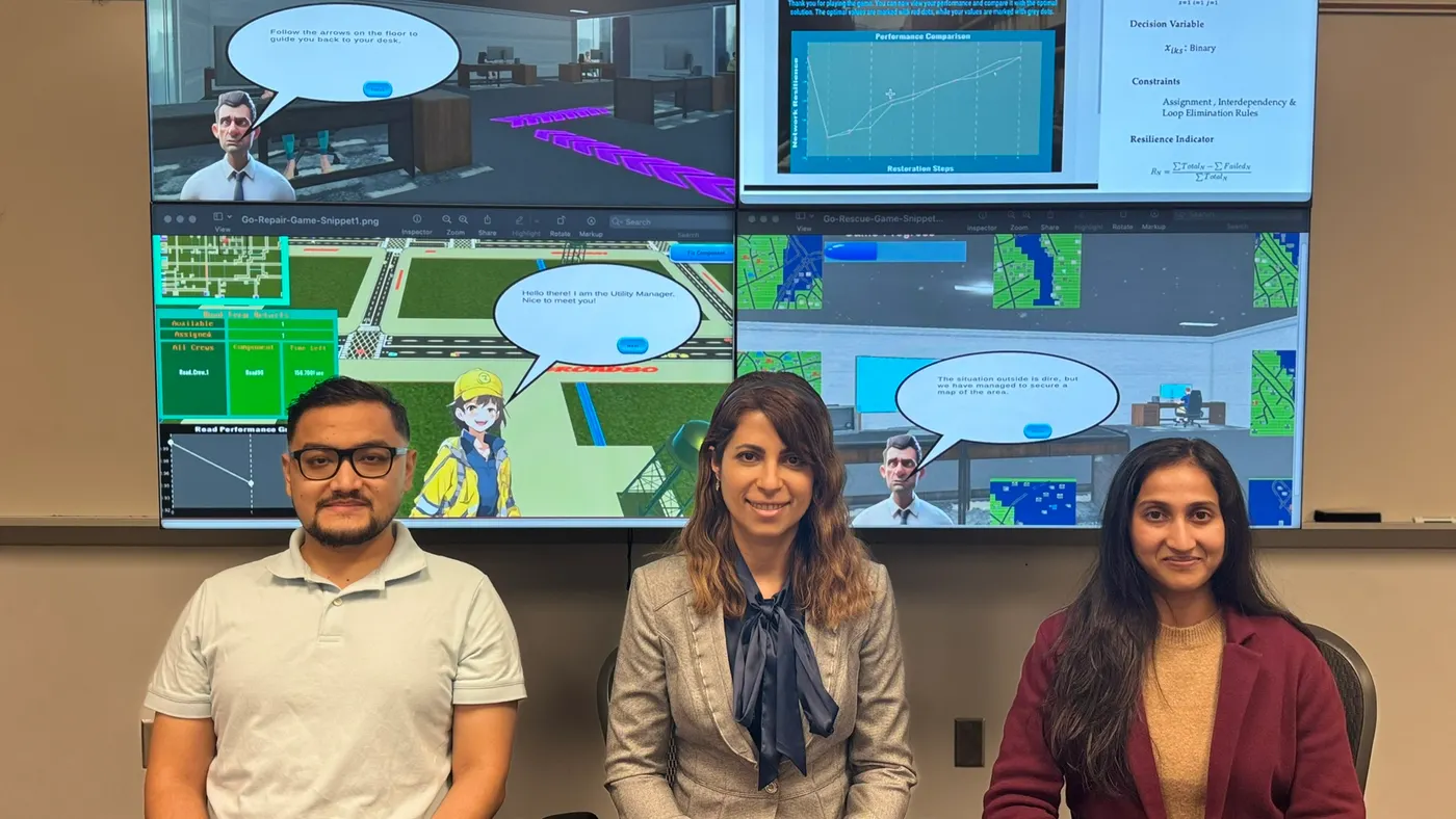
How Arlington County used AI to improve emergency preparedness
The Virginia county’s Department of Public Safety Communications and Emergency Management worked with George Mason University researchers to develop AI-enhanced video games for skills-building.
By: Lindsey Wilkinson• Published Feb. 5, 2025
Emergency response management is a high-stakes space. Each decision can mean life or death, which makes training and preparing for these scenarios critical.
Over the course of a year, a three-person team from George Mason University worked to improve preparedness via AI-powered games for the Department of Public Safety Communications and Emergency Management in Arlington, Virginia.
Using an iterative process and feedback from Arlington County department members, the team created two interactive games, called Go-Repair and Go-Rescue, which simulated infrastructure maintenance, resource allocation and evacuations. The dynamic learning environment provided utility managers and volunteers with a wider scope and more flexibility than traditional training methods.
Screenshot from the Go-Repair training game.
Permission granted by George Mason University
“AI optimization and reinforcement learning models calculate the optimal decisions, and this allows players to assess whether their decisions are better or worse comparatively,” said Shima Mohebbi, assistant professor in the Department of Systems Engineering and Operations Research at GMU and the project’s leader.
Incorporating AI into training enables the department to better identify areas of improvement in decision-making and provides a tool to learn from mistakes without real-world consequences. To avoid subjectivity often seen in large language models, the researchers developed a model with a mathematical foundation and used reinforcement learning.
Enterprises can also gain value from incorporating AI into training and workforce development, from adaptive learning platforms to AI-augmented skills assessments. More than 3 in 5 HR pros expect AI to wholly transform the way training is currently conducted, according to a survey by management consulting firm OC&C Strategy Consultants. Most respondents said they were looking to expand AI adoption to talent management.
To infuse AI into training, business leaders can choose off-the-shelf options. Most corporate training providers, including Coursera, Skillsoft and LinkedIn Learning, have added the technology to their tech stacks to some degree, and CIOs can also look into developing in-house solutions.
Mohebbi said leaders interested in developing a similar solution to Go-Repair and Go-Rescue should start by getting a clear understanding of the problem they want to address. To do that, Mohebbi’s team focused on connecting with stakeholders.
AI model decisions
Despite the current spike in interest regarding generative AI, Mohebbi’s team didn’t pursue that particular branch of artificial intelligence.
“The AI models that we are using are based on a mathematical foundation, not just generated based on past experiences,” Mohebbi said. “We really need to have that strong mathematical foundation to avoid the subjectivity we usually see in large language models.”
Hype alone isn’t enough to warrant implementation.
CIOs have had to work to rein in generative AI use cases and prioritize those with the most potential. The costly technology is not the best or most reliable tool in every situation.
“We want to look at AI, which is not a hammer looking for a nail, but [by being] clear in terms of what’s the business problem or context we are solving and how can AI enable us to do that,” Surabhi Pokhriyal, chief digital growth officer at Church & Dwight, said during the company’s analyst day last week.
Technology leaders who tease out generative AI’s weaknesses and lean on its strengths to prioritize use cases find success. Oftentimes that means fewer deployments. Leading organizations pursue about half as many generative AI opportunities on average compared to less advanced businesses, according to Boston Consulting Group.
As the GMU project developed, stakeholders raised questions about the reliability of the AI models used to power the training games.
Screenshot from the Go-Rescue training game.
Permission granted by George Mason University
“We added more information about these background algorithms,” Mohebbi said. “They were more comfortable afterward and enthusiastic about adopting the game.”
Implementing stakeholder feedback
Go-Repair and Go-Rescue function quite differently than they did initially. Mohebbi’s team created several versions before landing on the current functionality and capabilities.
“We held meetings and then provided a version and they would test it out and provide us with feedback,” Mohebbi said. “We’d address their feedback and provide them with an updated version. It was a very iterative process.”
One of the first changes was also the biggest. The game was initially designed to be played offline, but security protocols within the department wouldn’t allow downloads. Mohebbi’s team then shifted to web-based development.
Mohebbi’s team also added visual elements, improved user experience, enhanced the localized scenarios and provided more insight into user decisions and their consequences throughout the process.
The partnership between technologists and end users was crucial to the project’s success.
“If it wasn’t for the feedback and our interactions with Arlington County, we wouldn’t even know about the certain specifics and features needed,” Mohebbi said.
Article top image credit: Permission granted by George Mason University
The latest data & technology powering smart cities
After years of research, cities are beginning to use advanced technologies and data to address real-world problems like homelessness and the digital divide. They’re also preparing for fundamental changes in how people live, work and play by experimenting with newer technology such as the metaverse and EVs.
included in this trendline
The Olympics are headed to LA. So is free Wi-Fi.
Commentary: How one county is benefiting from digital asset lifecycle management
California city adopts AI permitting
Our Trendlines go deep on the biggest trends. These special reports, produced by our team of award-winning journalists, help business leaders understand how their industries are changing.