Dive Brief:
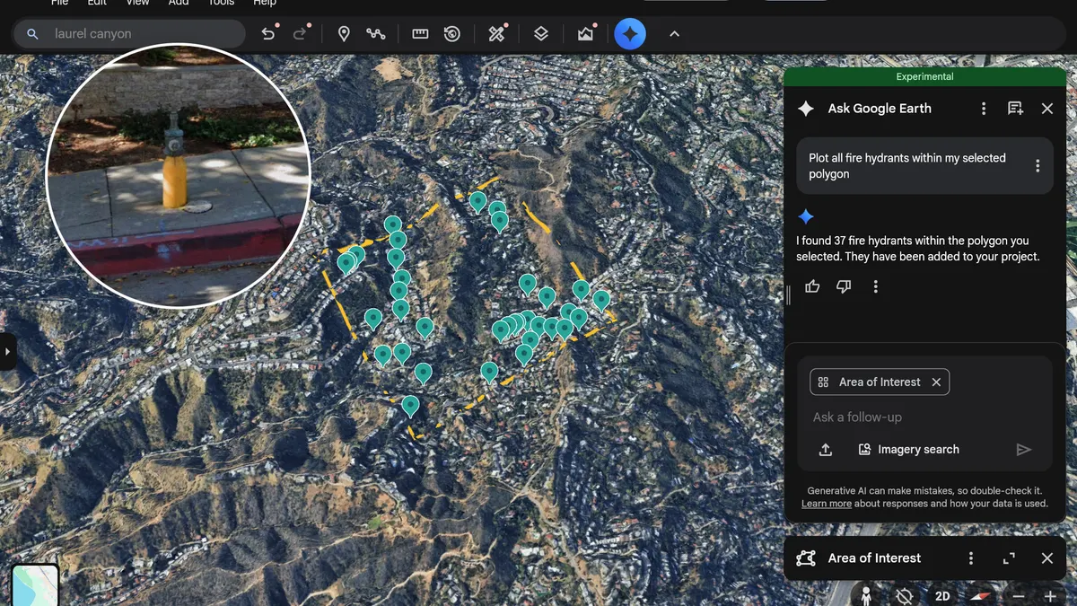
- Google’s Ask Google Earth platform now allows users to locate specific types of infrastructure within defined areas, a feature the tech company said could streamline workflows for urban planning and analysis.
- The feature, announced last year, moves the company’s infrastructure data into BigQuery, Google’s AI data analytics platform. The update lets users track fire hydrants, speed limit signs, stop signs, street lights, traffic lights, utility poles, storm drains and manhole covers.
- Users can also access images pulled from Google’s Street View “to identify, detect, and see the condition of key infrastructure objects, like utility poles, street signs, roads, and bridges,” the company said.
Dive Insight:
U.S. infrastructure received its highest-ever grade from the American Society of Civil Engineers’ quadrennial report card last year. It was a C, up from a C- in 2021.
Despite that progress, mayors said infrastructure was less of a priority than it had been in previous years, according to a 2025 National League of Cities survey. Typically among mayors’ top one or two priorities, infrastructure fell to fourth place in the survey.
That drop is likely due to financial impacts of tariffs and bond issues on cities, Farhad Omeyr, director of research and data for NLC, told ASCE last year. Dwindling funds from the 2021 Infrastructure Investment and Jobs Act may also play a role in infrastructure’s priority dip.
“But if it is, it’s not a good sign,” Omeyr said. “Just because there’s no longer money, it’s not like these issues are suddenly fixed.”
Cities are tightening their budgets, another NLC survey found. Google touted its new Ask Google Earth feature as a way to help cities make the most of their infrastructure funds.
“For example, if you are a city planner needing to determine your annual budget for road sign repairs, Imagery Insights can help you identify the exact number and locations of signs requiring attention using Street View imagery,” the company stated. “This integration streamlines operations, optimizes workflows, and enables smarter, data-driven decisions for improved planning and operational efficiency.”